

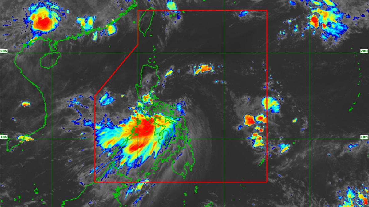
(UPDATE) Tropical Storm Dante (Choi-Wan) made landfall twice in less than an hour in Romblon, as it continues to move towards mainland Luzon to hit land and bring more rains that could trigger floods and landslides, PAGASA said.
Dante, the fourth storm of 2021, was spotted off Pola, Oriental Mindoro at 1 p.m., packing maximum sustained winds of up to 65 kph with gusts of 90 kph. It is forecast to pass near or over Oriental Mindoro or Batangas before making landfall over Bataan on Wednesday night, PAGASA said in its latest advisory.
It is expected to weaken into a tropical depression as early as Wednesday night,and is seen to traverse or pass near Zambales and Pangasinan early Thursday.
READ
Scores Evacuate, Learning Modules Destroyed in Dante Floods
Dante may bring moderate to heavy rains with at times intense rains over CALABARZON, Romblon, Marinduque, Occidental Mindoro, Oriental Mindoro, Aklan, Antique, Capiz, Bataan, Zambales, and Pangasinan.
Dante first made landfall in Sulat, Eastern Samar on Tuesday night. It also hit land in Cataingan and Balud, Masbate, and in Romblon and San Agustin, Romblon.
Signal no. 2, or winds of up to 61-120 kph within 24 hours, is raised over these areas:
LUZON
- Northern portion of Romblon (Corcuera, Banton, Concepcion)
- Marinduque
- Northern and central portion of Oriental Mindoro (Roxas, Bongabong, San Teodoro, Puerto Galera, Baco, City of Calapan, Naujan, Victoria, Socorro, Pola, Pinamalayan, Gloria, Bansud)
- Northern and central portion of Occidental Mindoro (Sablayan, Santa Cruz, Paluan, Mamburao, Abra de Ilog, Lubang Islands)
- Batangas
- Cavite
- Bataan
- Southwestern portion of Bulacan (Calumpit, Bulacan, City of Malolos, Paombong, Hagonoy)
- Western portion of Pampanga (Masantol, Macabebe, Sasmuan, Lubao, Floridablanca, Porac, Guagua, Santa Rita, Angeles City, Mabalacat City, Minalin, Bacolor)
- Zambales
- Western portion of Tarlac (Bamban, Capas, San Jose, Mayantoc, Camiling, Santa Ignacia, San Clemente)
- Western portion of Pangasinan (Bolinao, Anda, Bani, Agno, Burgos, Infanta, Dasol, City of Alaminos, Mabini, Sual, Labrador, Bugallon, Aguilar, Mangatarem, Bayambang, Urbiztondo, Basista, Malasiqui, San Carlos City, Santa Barbara, Mangaldan, Dagupan City, Calasiao, Binmaley, Lingayen)
Signal no. 1, or winds of 30-60 kph may be experienced in at least 36 hours, is up over these areas:
LUZON
- the rest of Romblon
- the rest of Oriental Mindoro
- the rest of Occidental Mindoro
- Western portion of Quezon (Sampaloc, Mauban, Lucban, City of Tayabas, Candelaria, San Antonio, Tiaong, Dolores, Sariaya, Pagbilao, Lucena City, Atimonan, Padre Burgos, Agdangan, Pitogo, Unisan, Gumaca, Lopez, Plaridel, Macalelon, Catanauan, General Luna, Buenavista, Mulanay, San Narciso, San Andres, San Francisco)
- Laguna
- Metro Manila
- Rizal
- the rest of Bulacan
- the rest of Pampanga
- the rest of Tarlac
- the western portion of Nueva Ecija (Cabiao, San Antonio, City of Gapan, San Isidro, San Leonardo, Jaen, Zaragoza, Licab, Guimba, Cuyapo, Nampicuan, Talugtug, Quezon, Aliaga, Santa Rosa)
- the rest of Pangasinan
- Southern portion of Benguet (Itogon, Tuba, Sablan, Baguio City, La Trinidad, Kapangan, Tublay)
- La Union
VISAYAS
- Aklan
- Northern portion of Antique (Tibiao, Culasi, Sebaste, Pandan, Libertad, Caluya)
PAGASA also warned of rough seas over the seaboards where signal no. 2 is hoisted and the remaining seaboards of Bicol Region, meaning sea travel is risky for small seacrafts.
Here is the track and intensity forecast for Dante:
