

Wet Week Ahead: Typhoon Jenny, Habagat to Bring Rains in Most of the Philippines
Bring your umbrellas.
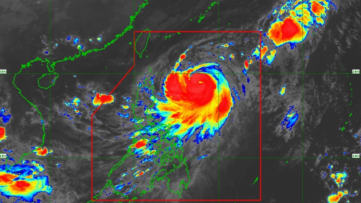
(SPOT.ph) Don't forget to bring your umbrella—expect a rainy week ahead as a new typhoon east of Cagayan enhances the southwest monsoon or Habagat for the next few days until it leaves the country later this week.
Jenny (international name Koinu)—the 10th tropical cyclone of the year—intensified into a typhoon early Monday, triggering tropical cyclone wind signal no. 1 in parts of northern Luzon. It continues to enhance the Habagat in southwest portions of the country, which may bring strong winds and heavy rains to parts of Southern Luzon, Visayas, and Mindanao.
The rest of the country may experience isolated rainshowers and thunderstorms, said Philippine Atmospheric, Geophysical, and Astronomical Services Administration (PAGASA) weather forecaster Obet Badrina.
Also read: Why Does PAGASA Name Typhoons After People?
What you need to know about Typhoon Jenny
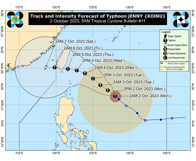
Jenny, located at 655 kilometers east of Aparri, Cagayan at 4 a.m., is packing winds of up to 120 kilometers per hour (kph) and 150 kph gusts. It continues to move northwest at 10 kph.
The state weather bureau said it is unlikely Jenny would hit Philippine landmass, but it is seen to make landfall in the southern part of Taiwan by Thursday before it exits the Philippine area of responsibility by late Thursday or early Friday.
Signal no. 1, which can mean strong winds to affected areas in the next 36 hours, is raised over:
- Batanes
- Babuyan Islands
- Eastern portion of mainland Cagayan (Santa Ana, Gonzaga, Buguey, Santa Teresita, Lal-Lo, Baggao, Gattaran, Peñablanca)
- Eastern portion of Isabela (Maconacon, Divilacan, Palanan)
This is Typhoon Jenny's track in the coming days:
Typhoon Jenny and the Habagat
The typhoon pulls the Habagat, which will dump rains in parts of Southern Luzon, Visayas and Zamboanga Peninsula. Rains brought in by the Habagat won't have tropical cyclone warning signals.
Also read: Habagat, Explained: Why They're Dangerous Like Typhoons
Heavy rainfall is expected in the following areas:
- October 2 (Monday) - Occidental Mindoro, northern portion of Palawan, Western Visayas
- October 3 (Tuesday) - Batanes and Babuyan Islands, northern portion of mainland Cagayan, Occidental Mindoro, northern portions of Palawan, Bataan, Zambales
These areas will experience gusty winds in the next three days:
- October 2 (Monday): Most of MIMAROPA, Western Visayas, and Bicol Region
- October 3 (Tuesday): Metro Manila, CALABARZON, MIMAROPA, Bicol Region, and Western Visayas
- October 4 (Wednesday): Bataan, the southern portion of Aurora, Metro Manila, CALABARZON, the northern portion of Palawan including Calamian Islands, Romblon, Occidental Mindoro, and portions of Bicol Region.
Also read:
What PAGASA's Yellow, Orange, and Red Rainfall Warnings Mean
The SPOT.ph Guide to What to Do Before, During, and After a Typhoon