
Egay Is In: What We Know So Far About the Potential Super Typhoon
As the monsoon brings rains in parts of Luzon and Visayas.

(SPOT.ph) A low pressure area east of Luzon has developed into a tropical depression named Egay, PAGASA said Friday, July 21 as it sees the possibility of the storm intensifying into a super typhoon by Monday or Tuesday.
Egay, the fifth storm of 2023 and the second one this July, was spotted 900 kilometers east of Southeastern Luzon with winds of up to 55 kilometers per hour and 70 kph gusts.
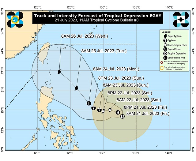
While it has no direct effect yet, PAGASA does not rule out a possible landfall scenario in the eastern parts of mainland Cagayan and Batanes before it is seen to head towards the southern islands of Japan.
The southeast monsoon or habagat will bring rains in the western section of Luzon and Visayas this Friday and will continue doing so in the next few days, said state weather forecaster Benison Estareja in a weather report.
Also read:
The Category Is Depression: Tropical Cyclones, Other Bagyo Terms Explained
Why Does PAGASA Name Typhoons After People?
What we know so far about potential super typhoon Egay
Egay is seen to move generally west northwestward until Sunday, before it moves northwestward over the Philippine Sea while inside the Philippine area of responsibility.
It is forecast to develop into a tropical storm this Friday and will continue to intensify and reach super typhoon category by late Monday or early Tuesday as it moves over the Philippine Sea.
In case you don't know, a super typhoon is a tropical cyclone with winds that exceed 185 kph or more than 100 knots. Under this category, Signal No. 5 may be raised.
Here's the track and intensity forecast as of July 21, 11 a.m.: