
The Category Is Depression: Tropical Cyclones, Other Bagyo Terms Explained
Because rainy days are here again.
(SPOT.ph) It's official: Rainy season is here, and along with it comes the possibility of more tropical cyclones coming in—meaning more tropical depressions, tropical storms, or even typhoon-strength rains and winds. But what do these terms mean, anyway?
It's common for the Philippines to be hit by strong storms during "ber months", like how the most powerful storm to hit land, Super Typhoon Yolanda (Haiyan), slammed the country in November 2013. More super typhoons followed, like Super Typhoon Rolly (Goni) in October 2020, Super Typhoon Odette (Rai) in December 2021, and Super Typhoon Karding (Noru) in September 2022.
In 2023 alone, some 10 to 14 tropical cyclones are expected to enter the Philippine area of responsibility, according to Philippine Atmospheric, Geophysical and Astronomical Services Administration (PAGASA).
Before it even reaches the super typhoon category, it goes through a process from being a brewing storm into a full-force typhoon that can potentially uproot trees, destroy homes, or even lead to death. It's important that we understand how tropical cyclones progress so we can prepare for them before they it.
Also read: Why Does PAGASA Name Typhoons After People?
How Tropical Cyclones Form
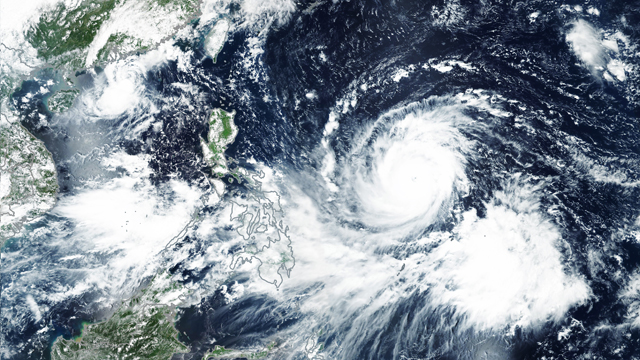
Basically, a tropical cyclone forms when there's warm ocean water—at least 27°C of sea surface temperature—near the equator in tropical regions (hence the name).
When warm water evaporates, it becomes water vapor (its gaseous form) which acts as fuel for the storm. As it goes higher, it leaves a low-pressure area below. Air rushes into that low-pressure area, which pushes more of that warm water up to evaporate.
When the water vapor condenses, it turns into water droplets. These form clouds, and when warm air continues rising upward, it blows in a circular pattern that forms the "eye" of the storm, surrounded by an eyewall, or a ring of thunderstorms that produce the heaviest of rains and strongest of winds.
Tropical cyclones can continue gathering strength while at sea as it is being "fed" by the energy from warm ocean waters, said NASA. It usually weakens when it hit land, but not before possibly causing destruction, usually in coastal areas.
Classifications of Tropical Cyclones
In the Philippines, we have five tropical cyclone categories based on the maximum sustained winds. In March 2022, PAGASA revised its categorization, specifically that of the super typhoon category, to mirror U.S. Joint Typhoon Warning Center's so as to avoid any confusion in forecasting.
When there's a low-pressure area brewing in or near the Philippine area of responsibility, PAGASA monitors whether or not it strengthens into a tropical storm, which follows these classifications:
Tropical depression (TD), the weakest in the five-tier categorization with winds of up to 62 kilometers per hour (kph) or less than 34 nautical miles per hour (knots), with the highest wind signal no. 1.
Tropical storm (TS), the second lowest, packs winds from 62 to 88 kph or 34-47 knots, with the highest wind signal no. 2.
When it intensifies further and reaches at least 87 kph winds (maximum 117 kph), it can become a severe tropical storm (STS). That's 48 to 63 knots, with the highest wind signal no. 3.
A tropical cyclone becomes a typhoon (TY), the second strongest category, if reaches winds of 118 to 184 kph or 64 to 99 knots, with the highest wind signal no. 4.
If it strengthens further and exceeds 185 kph winds or more than 100 knots, it becomes a super typhoon (STY). When this happens, signal no. 5 may be raised.
Read more: What Makes a Super Typhoon? The Most Powerful of Storms Explained
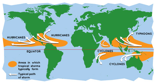
So how come the U.S. has hurricanes and the Philippines has typhoons? They're both tropical cyclones, except that it gets a name change depending on where the storm occurs, according to U.S. National Oceanic and Atmospheric Administration.
The term hurricane is used for weather disturbances in the North Atlantic, central North Pacific, and eastern North Pacific. If it's in the Northwest Pacific, it's called a typhoon. A tropical cyclone is the term used in the South Pacific and Indian Ocean, regardless of its strength.
Still can't understand it? Here's a visual from NASA:
Effects of Tropical Cyclones
Tropical cyclones are one of the most destructive natural disasters to happen across the globe, and it's not just because of strong winds and rains.
Even before rains hit, strong winds can be felt during tropical cyclones. We have to also be on alert for possible squalls (long periods of increased wind speeds) and gusts (short but rapid bursts in wind speed) which can also be damaging.
Some tropical cyclones can also produce tornadoes, or destructive funnel-shaped columns usually attached to thunderstorms, connecting them to the earth's surface.
Rainfall can both be beneficial and harmful, said PAGASA. While it can help fill dams with water or wet the ground for produce to grow, too much of it can also cause flooding which can last hours or days, even weeks in some heavily inundated areas. It can also cause loss of life by drowning.
Storm surges or daluyong, like the massive ones that hit Tacloban when Super Typhoon Yolanda barreled through the province, can be destructive. It is the abnormal rise of seawater during a storm measured by its height above normal sea level. When a tropical cyclone nears coastal areas, strong winds could push the water toward land, which can lead to flooding.
Those in storm surge-prone areas must know where to evacuate, usually to higher, safer grounds.
Also read: Why Does it Get so Hot in Dagupan During the Dry Season?