

What to Expect as Egay Intensifies Into a Super Typhoon
Ready those umbrellas.

(SPOT.ph) Tropical cyclone Egay has intensified into a super typhoon on Tuesday, July 25, bringing Signal No. 5 rains in Northern Luzon where it could make landfall, according to the Philippine Atmospheric, Geophysical and Astronomical Services Administration (PAGASA)'s latest bulletin.
The super typhoon with the international name Doksuri was located at 230 kilometers northeast of Tuguegarao City as of 1 p.m. on Tuesday, packing sustained winds of 185 kilometers per hour (kph) with 230 kph gusts. It is seen to reach its peak intensity within the day, PAGASA said.
By Wednesday and Thursday, Egay could bring strong winds to Visayas.
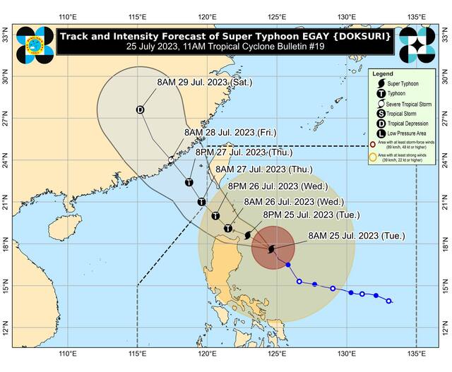
“The Southwest Monsoon enhanced by Egay will continue to bring occasional to monsoon rains over the western portions of Central Luzon, Southern Luzon, and Visayas in the next three days,” PAGASA said. It is forecasted to exit the Philippine area of responsibility on Thursday morning.
Egay is the Philippines’ fifth tropical cyclone in 2023 and the second one this July.
Also read: Why Does PAGASA Name Typhoons After People?
Super Typhoon Egay's effect
Heavy rain is expected across the mountainous northern provinces in the coming days, with landslides "highly likely" as per PAGASA. Coastal communities on the Babuyan islands have since been evacuated for safety.

Signal Number 5
Severe impacts from super typhoon-force winds may be experienced within areas under Wind Signal No. 5. People and animals exposed to the wind are at great risk of injury or death. Vast majority of trees will be broken or unrooted. Electricity, water supply, and telecommunications will be unavailable for prolonged periods of time from infrastructure disruption.
The eastern portion of Babuyan Islands (Camiguin Island)
Signal Number 4
Significant to severe impacts from typhoon-force winds may be experienced within areas under Wind Signal No. 4. Houses of poor and average construction may receive major damage like complete roof failure and possible wall collapse. Near total loss of power supply and telecommunications will occur.
The northeastern portion of mainland Cagayan (Santa Ana and Gonzaga) and the rest of Babuyan Islands
Signal Number 3
Moderate to significant impacts from storm-force winds may be experienced within areas under Wind Signal No. 3. Some large trees are broken. There is minimal disruption in telecommunications and water supply.
The northeastern portion of Isabela (Divilacan, Maconacon, Palanan, Santa Maria, San Pablo, Santo Tomas, Cabagan, Tumauini), the rest of Cagayan, Apayao, eastern portion of Ilocos Norte (Vintar, Adams, Pagudpud, Dumalneg, Nueva Era, Carasi, Bangui, Piddig, Solsona), northeastern portion of Kalinga (Rizal, Pinukpuk) and Batanes
Signal Number 2
Minor to moderate impacts from gale-force winds may be experienced within areas under Wind Signal No. 2. Some electrical wires may be blown down, resulting in local power outages. Houses of poor and average construction may receive minor roof damage.
The rest of Isabela, northern and central portions of Aurora (Dilasag, Casiguran, Dinalungan, Dipaculao), Quirino, the rest of Kalinga, northeastern portion of Nueva Vizcaya (Kasibu, Quezon, Diadi, Bagabag, Ambaguio, Villaverde, Solano, Bayombong), the rest of Ilocos Norte, Ilocos Sur, Abra, Mountain Province, Ifugao, northern portion of Benguet (Bakun, Mankayan, Buguias, Kabayan, Kibungan, Atok) and northern portion of La Union (Bangar, Sudipen, Luna, Balaoan, Santol)
Signal Number 1
Minimal to minor impacts from strong winds are may be experienced within areas under Wind Signal No. 1. Structures with light materials will suffer minor damage, with minimal disruption to public transportation.
Quezon including Pollilo Islands, the rest of Aurora, the rest of Nueva Vizcaya, the rest of Benguet, the rest of La Union, Nueva Ecija, Pangasinan, Tarlac, Zambales, Bulacan, Pampanga, Bataan, Marinduque, Cavite, Metro Manila, Rizal, Laguna, Batangas, Camarines Norte, Camarines Sur, Albay, and Catanduanes
Also read: The Category Is Depression: Tropical Cyclones, Other Bagyo Terms Explained