
PAGASA: Carina Now Super Typhoon, Expect Rains Till Sunday
Carina is expected to exit PAR by Thursday.

(SPOT.ph) Carina is now a Super Typhoon, as confirmed by PAGASA during their 5 p.m. tropical cyclone bulletin. It's the third day of continuous rains in Metro Manila and if you're wondering when we'll get to see the sun again, well, the recent upgrade to a super typhoon combined with PAGASA's latest five-day weather outlook spells rains until Sunday, July 28.
Also read:
Flood Gates Opened as Marikina River Hits Highest Alert Level
LIST: Malls Offering Shelter During Typhoon Carina
PAGASA: Carina now a Super Typhoon, rains to persist until Sunday
Carina upgraded to a super typhoon with maximum sustained winds of 185 km/h, accoridng to the weather bureau. The center of the eye was estimated to be at 380 kilometers north of Itbayat, Batanes.
Carina is expected to make landfall in Taiwan—which is within the Philippine Area of Responsibility (PAR)—this evening, Wednesday, and make its exit from PAR by Thursday morning. It is expected to weaken upon landfall in Taiwan and eventually make its final landfall over southeastern China by tomorrow, too.

In PAGASA's five-day regional weather outlook posted today, July 24, the weather bureau reported the likelihood of rain over the National Capital Region persisting until Sunday. While Carina is expected to exit by Thursday, occasional rains will continue while Friday will have rainshowers; come the weekend we might finally get to see some sunshine, but with accompanying rainshowers. The rains will persist over Metro Manila and most of Luzon, from Tarlac to Batangas and Quezon. This issuance remains valid until 9 a.m. tomorrow, when the bureau will issue another outlook for the next five days.
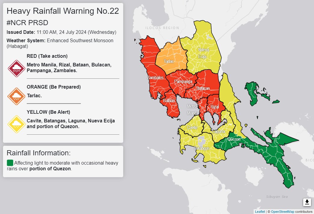
PAGASA's latest heavy rainfall warning placed Metro Manila, Rizal, Bataan, Bulacan, Pampanga, and Zambales on the Red level; Tarlac is on Orange; and Cavite, Batangas, Laguna, Nueva Ecija, and portions of Quezon are on Yellow. A red rainfall warning means serious flooding in flood-prone areas.
Also read: The Category Is Depression: Tropical Cyclones, Other Bagyo Terms Explained
Where is Typhoon Carina now?
The continuous rains from Typhoon Carina have resulted in floods and landslides all over the country. Government work and classes tomorrow, July 24, have already been suspended, according to the Palace.
As of this morning, Signal No. 2 has been raised over Batanes, with locals warned of gale-force winds reaching up to 88 kph. Meanwhile, parts of Luzon is now under Signal No. 1. This includes the Babuyan Islands, northern parts of Cagayan, and the northern parts of Ilocos Norte.
UPDATED (July 24, 2024): This article was updated following PAGASA classifying Carina as a super typhoon.