

What to Expect in the Coming Days as Supertyphoon Mawar Nears
Ready for a rainy weekend?
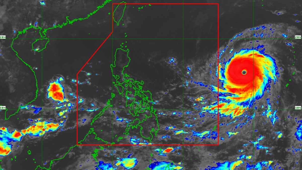
(SPOT.ph) Supertyphoon Mawar strengthened further while at sea on Friday, May 26, hours before it is seen to enter the Philippine area of responsibility, PAGASA said. The state weather bureau warned of possible signal no. 3 rains in some parts of Luzon by Monday or Tuesday next week, May 29 to 30
Mawar—the strongest storm so far this 2023 according to Joint Typhoon Warning Center (JTWC)—may enter PAR by Friday night or Saturday early morning. While it still has no direct effect and is unlikely to make landfall, it is seen to enhance the southwest monsoon or habagat, bringing rains over parts of northern Luzon and the eastern seaboards of the country by next week.
The second tropical cyclone to enter the country, which will be called locally Betty, was last located 1,705 kilometers east of southeastern Luzon at 10 a.m., packing maximum winds of 215 kilometers per hour and 260 kph gusts. It continues to move west at 20 kph, said weather forecaster Anna Clauren-Jorda during a press briefing.
While this weekend could be wet, it's likely due to the southwestern wind flows (or winds blowing from the southwest) and localized thunderstorms as the rainy season nears and may be declared as early as next week, PAGASA said this Friday.
Also read:
How to Avoid Getting Struck By Lightning During a Thunderstorm
What Do NAIA’s Yellow and Red Lightning Alerts Mean?
What You Need to Know About Supertyphoon Mawar
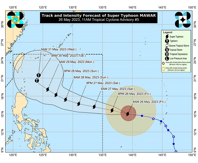
Mawar is seen to strengthen further while at sea and may reach 220 kph maximum sustained winds. It is seen to maintain its supertyphoon strength until Monday or Tuesday, when it could slightly weaken into a typhoon category, said Jorda.
"Hindi po tayo dapat makampante na hihina itong bagyo. 'Yung typhoon category malakas pa rin, posible pa ring umabot sa 175 kph ang kanyang maximum sustained winds."
Based on the cone of probability, once Mawar enters PAR, its outer rainbands can dump rain on Batanes, Babuyan Islands, and parts of mainland Cagayan as early as Monday.
Once it enhances the habagat, it will bring moderate to heavy monsoon rains over Central and Southern Luzon, and the western section of Visayas and Mindanao as early as Sunday. Expect rains in Metro Manila and other nearby provinces by Tuesday and Wednesday too, she said.
Since its radius reaches 500 kilometers, "hindi po natin inaalis ang posibilidad na magtaas pa rin tayo ng tropical cyclone wind signals," said Jorda.
"Ito pong si Mawar o si Betty, ang pinakamalapit n'ya po na landmass o probinsya sa atin ay itong Batanes, Babuyan Islands at itong mainland Cagayan. Posible po tayo ditong magtaas ng Tropical Cyclone Wind Signal No. 3 sa Batanes, Babuyan Island."
"Less likely pa rin po ang landfall scenario natin lalo na sa mainland Luzon," she said.
Despite this, PAGASA reminded the public to be on alert for any developments. Mawar is still far, and forecasts can still change.
"Paalala lang po, 'yung bagyo po ay habang nasa dagat ay masyadong dependent on atmospheric condition, nagbabago ang kanyang lakas, bilis at direksyon kaya po kailangan patuloy tayong mag-antabay o monitor sa updates ng PAGASA para sa agarang kaalaman natin," said Bonifacio Pajuelas, PAGASA-NCR's weather services chief.
Read more: GUIDE: How to Report Power Outages to Meralco